
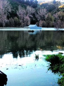
The massive slip which has dammed the Kaiwhata River and left a major scar on the hillside. PHOTOS/SUPPLIED
Residents advised to stay away from water
GIANINA SCHWANECKE
[email protected]
The massive slip which has dammed the Kaiwhata River between Te Wharau and Homewood remains firmly in place while water levels continue to rise.
It begs the question of what happens when the dam eventually breaks.
A team from GNS Science were at the site on Thursday to collect data to answer this question, using a drone, GPS and terrestrial laser scanner to provide detailed hazard information to local authorities.
The landslide which caused the dam is believed to have occurred some time last Saturday afternoon where the base of an existing landslide from a few years ago gave way.
The landslide that blocked the river has a volume of 100,000 cubic metres. The team measured the lowest point on the crest of the landslide dam as 15 metres above the original river level.
The volume of water in the lake forming behind the dam was estimated to be 600,000 cubic metres on Friday afternoon.
It was expected to spill over the top of the dam at some point on Saturday if water levels continued to rise.
Brenda Rosser, an engineering geomorphologist and sedimentologist from GNS Science, said a team was running through a 3D model they made based on Thursday’s site visit.
“We are running models to understand what would happen if the dam were to fail,” she said.
“We think there is a fairly high probability the dam will fail in the next few days.”
She said the cause of the landslide was still unknown.
“There are several large prehistoric landslides in the area, but we don’t know. We’re looking into that.”
Meanwhile, Kummerstein farm manager Marty Byl said the water was still rising about 2-3 centimetres every hour on Friday.
“We’ve got a lot of water now.”
He said the water did not seem to be breaching the dam, and water levels continued to rise with the wet weather – the farm recorded about 20mm of rainfall on Wednesday.
“We’ve got a real good dam – it’s wall to wall,” he said. “It’s very solid.”
Stock had been shifted from the flooded area but Byl was hopeful the water would recede soon as it covered flat land used for finishing.
“Maybe 20 hectares of my land is underwater now. It had good grass on the flats for finishing cattle.
“If the water hangs around for a week, we’ll just have silt, so there’s all our finishing country gone.”
He said the woolshed was also at risk of going underwater if the water levels did not go down and there were concerns about uplifted logs from a felled tree doing major damage.
The Kaiwhata Rd remains closed from the Te Wharau Rd intersection with further signage at the Kummerstein boundary.
The Carterton District Council is working with GNS Science to mitigate any potential dangers.
Infrastructure, services and regulatory manager David Gittings said he was thankful the slip had occurred in a remote area which meant no one was in any danger.
“Hopefully it will start to carve itself down slowly. If the dam did give way, it’s likely to follow the path of the river.”
He had been in contact with affected residents and advised them to stay out of the water and avoid working in lower areas of the valley in case the dam broke unexpectedly.