
Cape Palliser Rd. PHOTOS/FILE
‘We’ve got to keep the road open’

Further strengthening plans have been proposed for Cape Palliser Rd, where coastal erosion has been plaguing residents for years.
Engineering company WSP said in its road resilience report to South Wairarapa District Council that “ongoing coastal erosion and slope movement has highlighted the need for a management strategy to mitigate risks to the road and increase its resilience”.
For WSP, this was “especially important since Cape Palliser Rd is a key access route to several settlements along this stretch of coastline”.
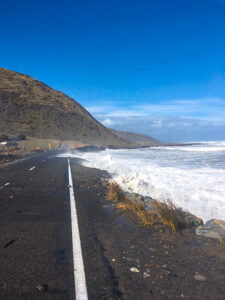
SWDC assets and services committee chairman Brian Jephson said he had seen the beach by the road disappear in his lifetime.
“In the last 40 years, it has gone from where you could play beach cricket to where you are in the water,” Jephson said.
WSP also acknowledged the reduction of the size of the beach in its report and said it had been reduced significantly over the past half-century.
WSP found that parts of the cliff erosion were due to not only coastal erosion, but also water run-off.
At one site, the cliff was made of material that eroded easier, and had no vegetation to aid against erosion, WSP said.
“The landscape around Cape Palliser Rd has a history of coastal retreat and slope instability. Ongoing coastal erosion has resulted in significant direct damage to the road during major storm events and sea swells,” WSP said in its report.
“The road is also impacted large-scale landslide at Johnson’s Hill, which has caused road damage on multiple occasions and continues to pose a risk to vehicle access.
“This landslide has shown renewed movement since the Kaikoura earthquake in November 2016.”
WSP said that historic photographs at Whatarangi Bluff showed the road’s vulnerability to wave erosion at the toe which led to slumping.
Jephson said the council was hoping to hold on to New Zealand Transport Agency’s special purpose funding for the road for a while longer.
“We’re hoping this funding will stay there a bit longer, but they want to stop funding on the road. We’ve got to keep the road open; it services a very popular spot, a lot of money comes out of there with crayfishing and farming,” Jephson said.
Jephson said the report “didn’t give us a silver bullet, it gave us some options that we could use to slow it down. We’ve got to take a good long look at it”.
Jephson said he had a lot of faith in the eco-reef project to reduce sea erosion – “if that’s proven, I think we could control it or slow it down”.
He said climate change was a big contributor to the future of the road, notably regarding sea level rise.
The council said in its agenda that a funding application had been submitted to NZTA for further work to be completed.
District Mayor Alex Beijen said the council would continue to survey the area to learn as much about it as it could.