Previously unknown active faults have been discovered in Wairarapa, providing fresh insights into the region’s shaky past and future.
A GNS Science team recently completed work to update Wairarapa’s known active faults using advanced LiDAR [light detection and ranging] technology.
Wairarapa is situated in the Hikurangi Subduction Zone, where the Pacific and Australian Plates collide.
There are a multitude of faults that exist throughout the valley – the main one being the Wairarapa fault, which last ruptured in 1855, producing “one of the strongest continental earthquakes ever observed”, according to Repeated giant earthquakes on the Wairarapa fault, New Zealand, revealed by Lidar-based paleoseismology, a report published in 2020.
The research came about with a revision of the Wairarapa Combined District Plan, which needed the best available natural hazards information.
Any fault that has been known to move within the past 125,000 years is described as active, GNS Science said.
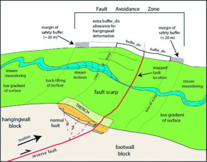
“During a large earthquake, surface ruptures may occur along active fault zones. Intense ground movement can result in deformation, caused when the opposite sides of the fault move past each other.”
Earthquake geologist Nicola Litchfield said although the faults were labelled as “new”, they have actually been around for tens of thousands of years: “They are just new to us.”
“Knowing where active faults lie in our regions is important, particularly for town planning purposes.”
Litchfield said having the best information about local earth structures and being able to forecast where movements are likely to occur in a significant earthquake means regions have the ability to plan better for hazard resilience.

A Wellington Region Emergency Management Office [WREMO] spokesperson said emergency management remains the same because emergency planning is based on expected impacts rather than individual faults.
“While there have been more faults found in Wairarapa, there will be many still that we are yet to uncover across Aotearoa,” it added.
“The discovery of new Wairarapa faults reiterates that we live in a seismically active place in the world and highlights the importance of communities understanding their risk and taking steps to be prepared.”
WREMO said local councils in Wairarapa, as part of the Civil Defence Emergency Management Group, have the latest science to help inform their local and district plans.
Some of the newly identified Wairarapa faults are southeast of Carterton crossing Carters Line, west and southeast of Greytown near Woodside and Pāpāwai, while a series of northeast-orientated faults lie to the north of Masterton, between the Masterton and Mokonui faults, GNS Science said.
“Gathering information about faults over large geographical areas is no quick process so, for this initial stage of the Wairarapa work, the GNS Science team has prioritised the most important faults and those near the valley’s towns.”
It said Fault Avoidance Zones have already been developed for faults in the valley, which include the setback zone that scientists recommend being applied in fault locations where “structures and activity should be avoided”.
This week, Litchfield and paleoseismologist Genevieve Coffey were back in Wairarapa collecting soil samples that will be analysed and used to date landforms that were offset by faults up to tens of thousands of years ago.
Greater Wellington Regional Council group manager of environment Lian Butcher said the regional council will study the new GNS active fault mapping report to understand if it will impact its land use regulations and consenting in Wairarapa.
WREMO said earthquakes can happen at any time, which is why it urges communities to be prepared.
Further information on preparing for an earthquake can be found on WREMO’s website.


